Image via Twitter @robperillo screenshot

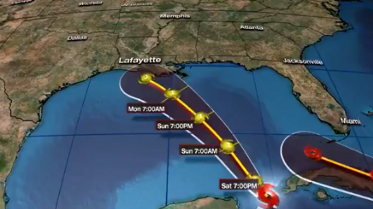
Historic tropical storms strengthening into potential hurricanes that could make landfall in Louisiana within 48 hours of each other
The National Oceanic and Atmospheric Administration predicted that the 2020 hurricane season would be busy with the potential for "extreme activity." But there was no way they could forecast the possibility of double hurricanes in the Gulf of Mexico at the same time because there have never been two hurricanes in the Gulf of Mexico at the same time in documented history. There are currently two storms marching towards the Gulf Coast of the United States.
"Official records go back to 1851. Based on the WPC (Weather Prediction Center) analysis, there is no record of two hurricanes at the exact same time in the Gulf of Mexico," an NOAA staffer told WABC-TV.
Tropical Storms Laura and Marco are barreling towards the Gulf coasts of Louisiana and Texas. Tropical Storm Marco has a head start and is already in the Gulf of Mexico, and is expected to make landfall on Monday. Tropical Storm Laura is predicted to arrive in the U.S. by Wednesday, exactly three years after Category 4 Hurricane Harvey smashed into Texas and caused catastrophic flooding Louisiana.
As of 5 p.m. EST, Tropical Storm Laura has sustained winds of 50 mph while dumping heavy rains on Puerto Rico and is headed to the Dominican Republic, according to the NOAA. Tropical storm warnings were issued to Puerto Rico, the U.S. and British Virgin Islands, Haiti, the Bahamas, and the Florida Keys. A hurricane watch has been posted on the Louisiana coast.
As of 4 p.m. EST, Tropical Storm Marco is east of the Yucatan Peninsula with sustained winds of 65 mph and is expected to develop into a Category 1 hurricane by Monday.
The storms are currently forecast to make landfall as hurricanes, but upper-level shear ahead of the storms is expected to weaken them both before hitting Louisiana or Texas.
The latest forecast from the NOAA predicts that both storms will make landfall as Category 1 hurricanes near New Orleans. It's 2020, why would you expect anything less than double hurricanes.
Despite the systems following similar paths and being in close proximity, experts say that they can not combine to become a "supercane."
"That's because each system has sinking air on its outskirts, which presses down on the other system," CBS News reported. "So, when two systems are that close, the larger one tends to weaken the smaller one. And in some cases they can even dance around one another in a phenomena called the 'Fujiwhara effect.'"
Tropical Storm Laura was the 12th named storm of the hurricane season, and Marco was the 13th. This hurricane season ties 2005 for the record of the highest number of tropical storms before September. The 2005 hurricane season was especially destructive with Hurricanes Katrina and Wilma.